
When will Idalia hit Tampa? Latest Updates On Hurricane
TAMPA, Fla. (FLTrendz) — Hurricane Idalia is approaching Florida’s Gulf Coast. As Idalia approaches, storm surges are expected across the Tampa Bay area. The Super Moon on Wednesday has led to higher-than-normal high tides, intensifying the threat of storm surges.The National Hurricane Center states that Idalia will bring “catastrophic” impacts from storm surge. The question remains: When will idalia hit Tampa Bay?
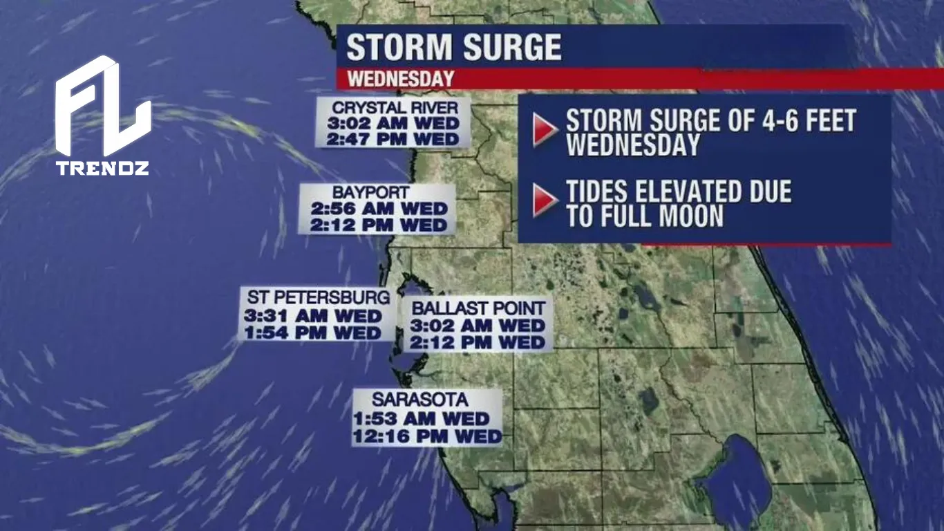
The most severe weather is expected from Tuesday night until Wednesday afternoon. The largest storm surge in the Tampa Bay area will happen after the storm’s eye passes on Wednesday afternoon.
Storm Surge
Storm surge is rising water caused by a storm, especially a hurricane, that can flood coastal areas.
Storm surge is the extra high water a storm brings on top of the expected tide. The combination of tide and storm surge might reach up to 20 feet. Historically, rising ocean water during major hurricanes led to significant loss of life.
Idalia Hurricane Tracking
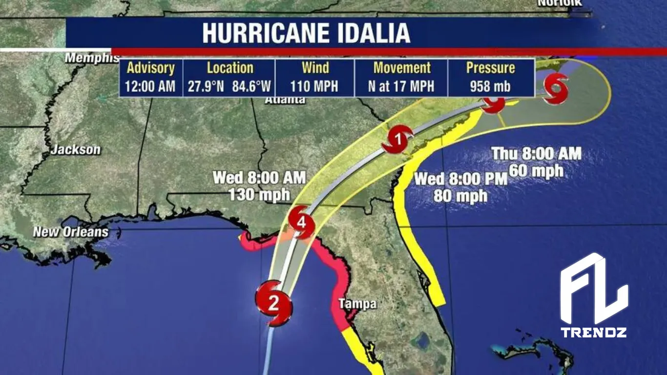
At 4 a.m., the National Hurricane Center reported Idalia about 90 miles southwest of Cedar Key, moving north at 17 mph. It’s a Category 3 hurricane with winds reaching 125 mph.
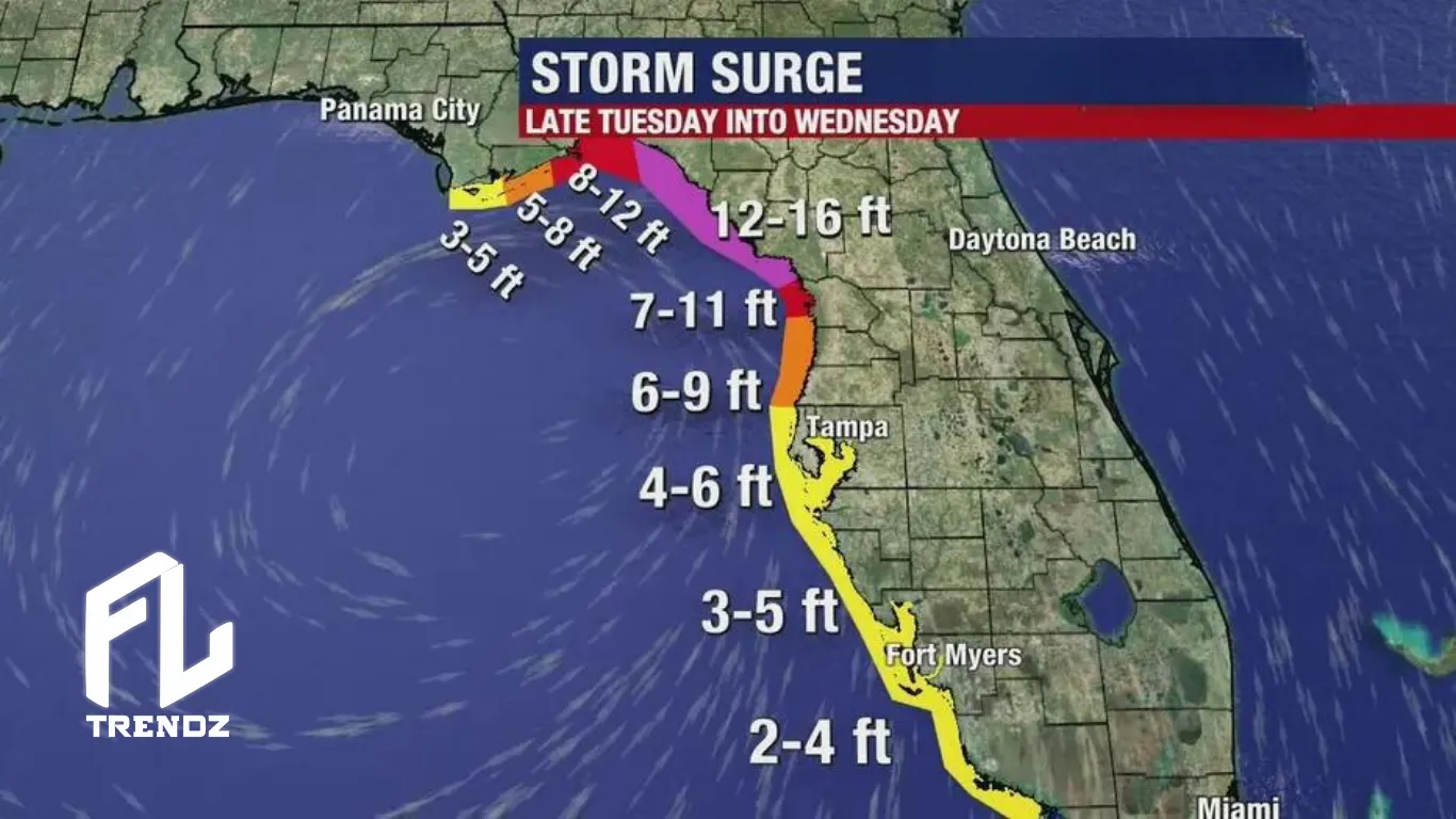
Expected to track west of Tampa, Idalia is predicted to hit the northwest Gulf Coast of Florida on Wednesday as a dangerous Category 4 hurricane. The main concern is the storm surge. Expected levels are 8 to 15 feet north of Tampa Bay, 4 to 7 feet within Tampa Bay, and 3 to 5 feet south of Tampa Bay around 1 p.m.
“The impacts will be a little stronger in our coastal counties,” Max Defender 8 Meteorologist Rebecca Barry said. “The worst of the surge is now in northern Citrus County. They did downgrade the surge for southern Citrus County to that 6 to 9-foot range instead of above 9 feet, so that’s good.”
Things will worsen from Tuesday night into early Wednesday as the storm approaches Florida.
Flooding forecast:
Citrus County:
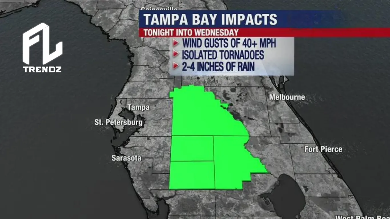
- Wind: Strong winds starting Tuesday night, possibly over 50 mph, with tropical storm force. Chance of isolated tornadoes.
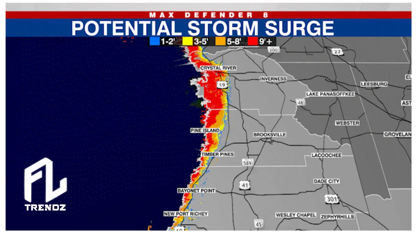
- Flooding: Coastal areas may face 6 to 9 feet of storm surge, peaking early Wednesday. Citrus County could see surges of 7-11 feet.
- Rain: Anticipate 5-10 inches of rain, leading to freshwater flooding.
Pasco and Hernando Counties:
- Wind: Tropical storm-force winds starting Tuesday night; gusts could exceed 50 mph—chance of isolated tornadoes.
- Flooding: Coastal areas might face a 6 to 9-foot storm surge, peaking early Wednesday. Citrus County could see surges of 7-11 feet.
- Rain: Anticipate 5-10 inches of rain, leading to expected freshwater flooding.
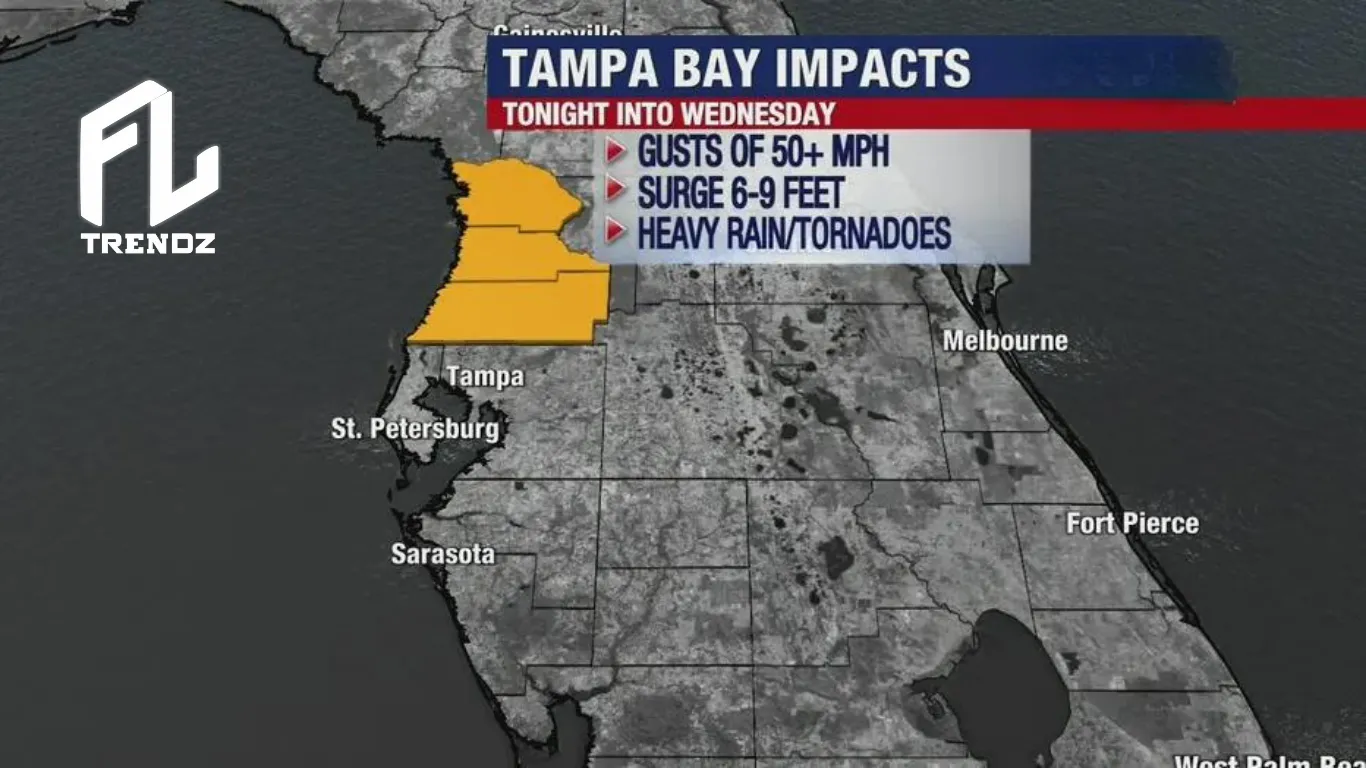
Pinellas and Hillsborough:
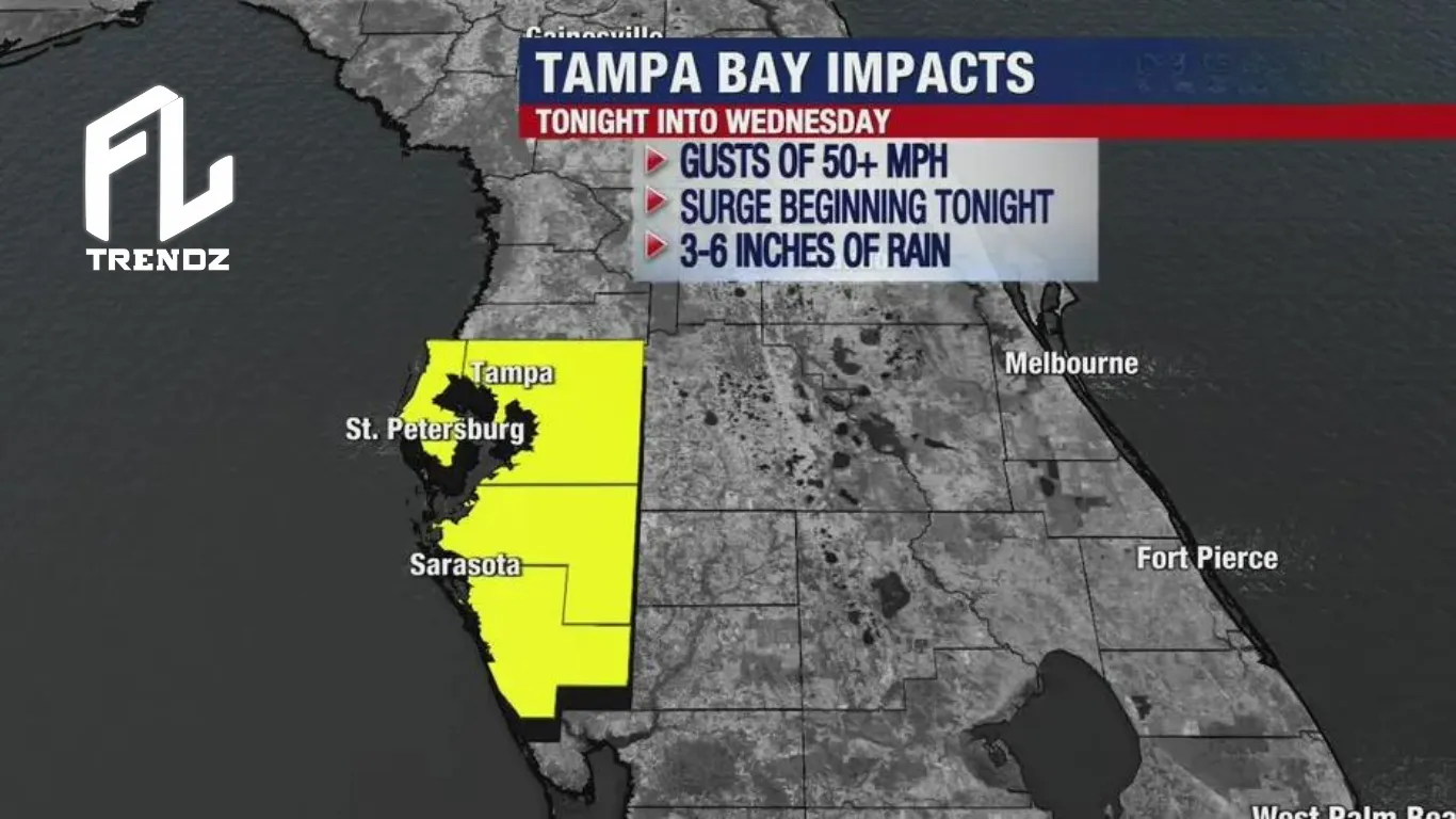
- Wind: Expect tropical storm-force winds starting Tuesday night, possibly over 50 mph.
- Flooding: Early Wednesday may bring a storm surge of 4 to 6 feet, leading to possible significant flooding.
- Rain: Overall, 3 to 6 inches of rainfall is expected, with isolated areas getting up to 10 inches.
Sarasota and Manatee Counties:
- Wind: Tropical storm-force winds start Tuesday night, with gusts over 50 mph possible. Chance of isolated tornadoes.
- Flooding: Chance of coastal flooding.
- Rain: Overall, 3 to 5 inches of rainfall is expected.
When will Idalia hit Tampa Bay?
Tampa: Hurricane Idalia is hitting the Tampa Bay area. It’s getting stronger and might become a Category 4 hurricane by Wednesday when it reaches us from the north.
There’s a hurricane warning for a big part of the Tampa Bay area, covering Citrus, Hernando, Pasco, Pinellas, Hillsborough, Manatee, and Sumter counties.
As Hurricane Idalia grew stronger on Tuesday, people in Tampa Bay hoped it might just brush past instead of hitting directly.
By Tuesday evening, the storm became a powerful Category 2 hurricane with winds at 110 miles per hour. It’s heading north at 17 miles per hour. The storm bands are already touching the Bay Area’s coast and spreading across the state.
The storm was expected to move close to Florida’s coast, gaining strength from the warm Gulf waters while passing west of Tampa Bay overnight. If it stays on this path, Tampa might dodge the worst.
But the Big Bend area, where the coast changes direction, is in the storm’s path. Officials urged evacuations there as this region hasn’t faced a major hurricane in a long time. Many people in this poorer, rural area live in vulnerable mobile homes. Some counties lack strong shelters and are sending people to Tallahassee.
In Tampa Bay, strong winds from outer bands caused power outages for over 1,000 people. By Tuesday evening, Idalia became a Category 2 storm with winds over 100 mph, intensifying about 190 miles southwest of Tampa. The latest update predicts Idalia to turn into a powerful Category 4 hurricane at landfall.
Local officials warned that even if the strongest winds miss Tampa, the storm’s water remains a serious threat to the area’s safety.
“The risks associated with a hurricane are much more than just the cone,” said Federal Emergency Management Agency press secretary Jeremy Edwards.
Meteorologist Dave Osterberg advises focusing on the storm’s cone rather than just its center line when checking computer models.
The Bay Area is on the storm’s right side, known as the ‘bad side’ by FOX 13 meteorologists. This means there will be a heavy buildup of winds along the coastline.
Storm surge is still dangerous
At a Tampa Home Depot, Jim bought a garden hose and soil bags, planning to use the soil as sandbags for the storm.
Concerned about storm surge and water, Jim knows even small surges can be very damaging, like in the 2020 Tropical Storm Eta. Last year, Hurricane Ian’s storm surge, not the wind, caused the most harm.
St. Petersburg anticipates a high tide around 2 p.m. Wednesday due to a full moon, which might raise water levels even after the storm. Flooding began in some areas on Tuesday.
Tampa Bay could see a surge of 4 to 6 feet, though maps show lower levels in most areas. Pasco County prepared for two surges, leaving limited time for rescues.
Officials at all levels urged those under evacuation orders to leave, highlighting the danger of storm surges.
“You’re not gonna win that battle if you decide to stay behind for that,” said Gov. Ron DeSantis at an afternoon news conference.
“Don’t take anything for granted,” Tampa Mayor Jane Castor said en route to one of the city’s three emergency response centers. “Mother Nature is ultimately in charge.”